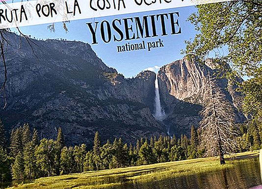
Today we start a route along the west coast of the United States by car. A route that will take us to know many of the great natural attractions of this country, with the starting and ending point in San Francisco and for 14 days. The first one starts strong: we visit Yosemite National Park.
We tell you what what to see and do in Yosemite, its points of interest, waterfall trails and viewpoints.
ROUTE INFORMATION
- Point: San Francisco
- Final point: Yosemite Bug
- Total miles: 250
- Estimated time: 9 hours
- Time dedicated to Yosemite: 4 hours
- Yosemite price: $ 30 per car (included in the America the Beautiful pass, available at any park in the National Parks network, valid for 1 year and priced at $ 80 per car).
- What to see in Yosemite National Park:
- Bridalveil Fall
- Viewpoint from below El Capitan (2,307 meters)
- Sentinel Beach
- Mirror lake
- View of the Half Dome (2,693 meters)
- Lower Yosemite Fall
- Cook's Meadow Loop
- Deer
The entrance to the park is from the west side and can be done from two roads: the 120 from a little further north and the 140. We did it from the latter.
The park has a mostly circular route of the valley. Entering Highway 140 you will follow the Merced River, with its rapids and rocks, to the turnoff to the right. Here you take a one-way road with two super well paved lanes. You can go making stops in the parking lots, which are distributed throughout the park, take photos or start a path, of the many there are.
The route reaches the camping area of Upper Pines, from here several trails lead to different sites. Once again in the car, you cross the Merced River to go this time along its other side (also one way road) until you reach the junction of the beginning and exit on the same road we entered.
It is best to do it by car, although there is also a free bus service that runs through the central part of the valley with up to 20 stops. You can get more information at Valley Visitor Center.
→ Park maps
The best time to visit Yosemite is May and June, coinciding with the thaw, when the waterfalls have the highest flow of the year. In September and October there may even be no water.
It is very easy to orient yourself in the park and in the same route in the car you can see many of the biggest attractions. Here are some of the most interesting points:
1. Waterfall entering on Highway 140
It is the first waterfall we find in the park, it is to the left of the road and is seen in the distance. With the desire we had, we began to climb the rocks to try to approach the waterfall, but there is not even a path and after 5 minutes we turned around. The truth is that it is not worth spending much time, later you see much better.

2. Viewpoint from below El Capitan (2,307 meters)
After taking the detour to the right and starting the loop, on the same road in a green esplanade you have the El Capitan rock of 2,307 meters high in front of you. It is not really the highest peak in the park, but the view of this granite mole rising before your eyes is one of the most impressive in the park.

3. Bridalveil Fall
It is the first path we take, which runs 0.4 miles from the parking lot to this waterfall. It ascends through the forest until it can almost touch the water that falls, it is actually the water that falls that touches you, when it explodes when it touches the ground and leaves blurred to all sides. But nothing compared to one that comes later ... read on.
If you want to walk Yosemite on foot and have time, from here start the Valley Loop Trail in case you feel like getting a fat kick (for example the Half Dome Village is 5.3 miles from here)

4. Glacier Point
Shortly before the Bridalveil Fall there is a detour to take the road that reaches the Glacier Point, through the Wawona Tunnel. In fact it is a fairly long road (32 miles and an hour approximately) and does not connect with other areas of the park, so it could only be done back and forth. We did not do it. Eye, this point is closed in winter.

Nps.gov photo
5. Sentinel Beach
One of the most spectacular places in the park. In this haven of the river you can put on your swimsuit and take a dip in the cold waters, there is also a picnic area and barbecues. But the most interesting are the views of the valley from the wooden bridge or better from the side of the car park on a log that floats on the water.

6. View of the Half Dome (2,693 meters)
The loop tour ends at the Pines camping area (Upper Pines is the farthest parking lot). On this road you can see in the background how Half Dome shows its head at a height of 2,693 meters. Being somewhat more hidden among the forest, the view is not as wonderful as that of the other colossus, but you certainly have to know it!
There is a path that ascends to the peak, but you need to ask for a special permit.

7. Mirror Lake
Once the car is parked in the Upper Pines parking you can take a path that reaches the Mirror Lake 1.3 miles. You can continue walking and make a circular route, about 5 miles, but the sun was already beginning to fall and we only had dinner beers in mind ... so we reached the point of Mirror Lake, which is actually a place where the river stagnates but it doesn't have a magic mirror effect either, the truth ... The path is fine, nothing from another world.
If you want you can opt for the path that goes south, the Mist Trail, which goes through some waterfalls, before continuing to the top of the Half Dome, but as we told you, to get to the highest point, you will need to ask for a permit . We did not, perhaps worth more than the Mirror Lake (do not be fooled by such suggestive names!).

8. Lower Yosemite Fall
The most spectacular waterfall in the park! It is the one that is seen in the background from Sentinel Beach and we do not even consider seeing it up close, but when passing with the car and having it there, we do not doubt it. From the parking lot is a 15-20 minute drive that takes you almost to get under water. The sensation of being in front of her, getting lost of water and with the tremendous roar of force with the fall reminded us of the boat trip through Milford Sound in New Zealand, where we were literally placed under the waterfalls.
Again if you have more time, you can take a tour that takes you to know the Lower and Upper Yosemite Fall. The route is not circular and has a distance of about 3 miles (it looks like it is not very simple and it cuts well up).

9. Cook's Meadow Loop
This trail of approximately 1.6 km has to be one of the most accessible and beautiful in the park. We didn't do it because time was on us, but it seems the views of the Half Dome reflected in the Merced River are the most! The trail leaves from the visitor center near the Yosemite Falls and crosses meadows and the river twice, in a loop counterclockwise. In 45 minutes you have it liquidated!

10. Forest with deer
In the last part of the park a forest with lots of deer is crossed, so be careful. Actually it seems that they are super accustomed to the trajín of the cars, they even put themselves to the sides taking out the head to see them pass! They are super handsome!

- Always check the official website updates about the state of the park, access roads, weather forecasts, etc.
- Download the map of Yosemite Park to prepare your itinerary.
- At the entrance to the park where the pass is paid or controlled they give you a map and some more info with which to plan the visit. It is not necessary that you approach the Visitor Centers, but if you have any doubts it never hurts.
- Along the park there are portable toilets, shaded areas and picnic areas. We also found some sources to refill the water bottle.
- In the park live bears that can give you a scare if you spend the night here. At night do not leave food outside if you do not want to be visited at dawn.
- Do not feed any animals!
- In most spaces pets are not allowed.
- You can camp in the park but only in the places intended for it and prior registration (there may be no places, but we do not know) and payment.
- There are also several accommodations where you can book, see below where we stay.
- Be careful because there are usually mosquitoes especially at the end of the afternoon. Take repellent and also sunscreen to avoid burning.
- Whether you have paid this ticket or if you have the America the Beautiful pass, you will have to put the ticket (or pass) in a visible place when you leave the car in a parking lot.
We did it at the Hi Yosemite Bug, a mountain resort that belongs to the Hostelling International network. The site has different types of rooms, from simple and affordable cabins to super cool bungalows! We stayed in a quadruple and it was great. We spent here one day. But the best thing about the place is its restaurant, with good dishes and cheap beer! It also has a spa area with a huge jacuzzi. It is about 30 miles (45 minutes) from the park.
- More information in your webpage.

Our recommendations
Flights Cheap to the United States: //bit.ly/2wNSTkb
accommodation Cheap in the United States: //booki.ng/2xgYVNj
Stay withAirbnb and get€ 25 discount: //www.mochileandoporelmundo.com/ir/airbnb
Activities in Spanish in the United States: //bit.ly/2wdvx5N
Rent a car with the best discounts: //bit.ly/2xGxOrc
Compare prices in the van rental: //bit.ly/2IFbMeB
Travel insurance IATI with a5% discount: //bit.ly/29OSvKt
West Coast Articles:
- THE 8 BEST EXCURSIONS FROM SAN FRANCISCO
- VISIT TO CRATER LAKE, IN OREGÓN
- 10 RESTAURANTS WHERE TO EAT IN LOS ANGELES (GOOD AND CHEAP)
- THE 10 BEST THINGS TO DO ON THE WEST COAST OF THE UNITED STATES
- 8 RESTAURANTS WHERE TO EAT IN LAS VEGAS (GOOD AND CHEAP)
- BUDGET FOR A TRIP TO THE US WEST COAST
- TRAVEL GUIDE TO THE WEST COAST OF THE UNITED STATES: EVERYTHING YOU HAVE TO KNOW
- WEST COAST OF THE USA STAGE 12: MONTERREY - SAN FRANCISCO
- WEST COAST OF THE USA STAGE 11: SAN DIEGO - LOS ANGELES - MONTERREY
- 25 THINGS TO SEE AND DO IN SAN DIEGO
- WEST COAST OF THE USA STAGE 10: PHOENIX - SAN DIEGO (SALVATION MOUNTAIN)
- 10 THINGS TO SEE AND DO IN PHOENIX
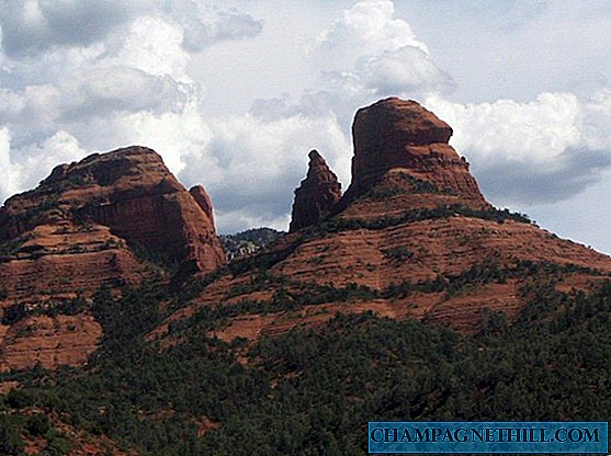
- WEST COAST OF THE USA STAGE 9: SEDONA - PHOENIX
- WEST COAST OF THE USA STAGE 8: MONUMENT VALLEY
- WEST COAST OF THE USA STAGE 7: CANYONLANDS AND DEAD HORSE POINT
- WEST COAST OF THE USA STAGE 6: ARCHES NATIONAL PARK
- WEST COAST OF THE USA STAGE 5: HORSESHOE BEND AND BRYCE CANYON
- TIPS TO VISIT THE GRAND CANYON
- 45 THINGS TO SEE AND DO IN LAS VEGAS
- WEST COAST OF THE USA STAGE 3: DEATH VALLEY
- WEST COAST OF THE USA STAGE 2: SEQUOIA AND KINGS CANYON
- WEST COAST OF THE USA STAGE 1: YOSEMITE
- TIPS FOR VISITING ALCATRAZ, THE MOST FAMOUS PRISON IN THE US
- 10 CURIOSITIES OF ALCATRAZ THAT WILL SURPRISE YOU
- TIPS FOR TRAVELING TO SAN FRANCISCO (AND DON'T FELL IT)
- 40 THINGS TO SEE AND DO IN SAN FRANCISCO
- 8 RESTAURANTS WHERE TO EAT IN SAN FRANCISCO
- VISIT UNIVERSAL STUDIOS DE LOS ANGELES: TIPS AND EVERYTHING YOU HAVE TO KNOW
- 40 THINGS TO SEE AND DO IN LOS ANGELES